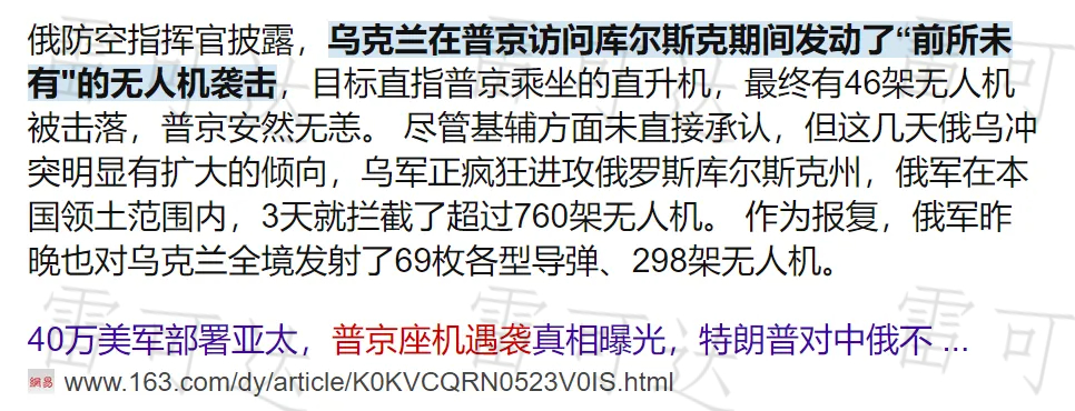
On May 25, 2024, according to Russian media reports, Russian President Putin’s helicopter came under a large-scale drone attack by Ukraine during his visit to the Kursk region. Although Russian air defense forces successfully intercepted and destroyed 46 incoming drones without causing any casualties, the incident once again highlights the asymmetric threat posed by drones and has drawn international attention to low-altitude security issues.
Drone Threats: From Military Battlefields to Daily Life
Drones, with their low cost, high flexibility, and strong concealment, are becoming a major challenge to modern security systems. Whether it is the frequent appearance of modified civilian “suicide drones” on the battlefield in Ukraine or the increasing number of cluster attacks in the Middle East, these incidents reveal the limitations of traditional air defense systems in dealing with emerging low-altitude threats. At the same time, the widespread use of civilian drones in areas such as agricultural plant protection, logistics delivery, and film production has also brought about significant security risks that cannot be ignored.
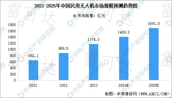
According to a report by the China Business Industry Research Institute, China’s civilian drone market reached 117.43 billion yuan in 2023 and is expected to exceed 169 billion yuan by 2025. While enjoying the benefits of technological advancements, how to effectively manage the various security risks brought by drones has become a major global challenge.
Countermeasure Solutions: Low-Altitude Security Radar Builds an "Invisible Sky Net"
Traditional air defense methods often struggle to effectively counter drones with “low-altitude, slow-speed, small target” (referred to as “low, slow, and small”) characteristics. Radar detection technology, as the core of counter-drone systems, is playing an increasingly critical role.
Radar systems operate based on the principle of emitting electromagnetic waves and receiving reflected signals. By analyzing the echoes, they can accurately obtain information such as the target’s distance, azimuth, altitude, and speed, providing precise data support for subsequent interception.
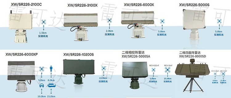
To address the unique challenges posed by “low, slow, and small” targets, Wuhan Lakeda has independently developed the XW/SR226 series of low-altitude security radars with full intellectual property rights. This series of products adopts advanced DBF technology and a multi-beam transmission mechanism, significantly improving the system’s anti-interference capability and detection sensitivity. It can detect, track, and display target trajectories in real time, providing reliable drone early warning and target indication services for key areas such as borders and airports.
Analysis of Technical Highlights of Star Products
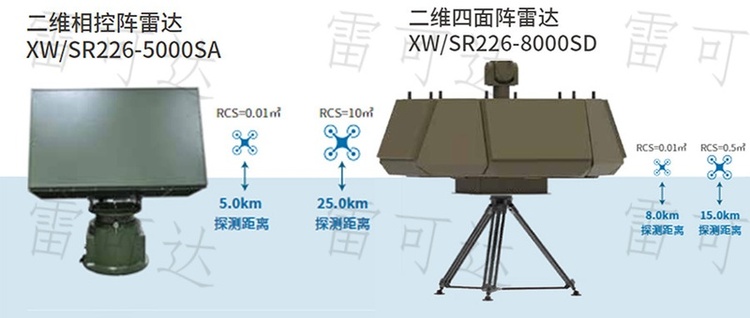
2D Phased Array Radar XW/SR226-5000SA: With “fast, accurate, intelligent, and stable” as its core features, it has become a key equipment for dealing with “low, slow, and small” targets, meeting the low-altitude economy’s demand for low-cost, multi-functional, and intelligent security solutions.
2D Four-Face Array Radar XW/SR226S6D: A three-coordinate radar specifically designed for drone detection. It employs S-band fully digital active phased array technology, integrates AI intelligent processing and a modular architecture, and achieves 360° full airspace coverage without blind spots. It can accurately capture tiny targets and is suitable for various scenarios such as border monitoring, airport protection, and critical site defense, serving as a new generation of intelligent perception hub.
Multi-Scenario Application Solutions
- Low-Altitude Drone Defense: Real-time detection of micro-drones within 8 kilometers, supporting integration with electro-optical systems to achieve a closed-loop "detection-control-strike" process;
- Border and Maritime Monitoring: All-weather monitoring of low-altitude cross-border targets within 15 kilometers, supporting audio-visual warnings and electronic fence interception;
- Airport Clearance Protection: Covers airspace within 10 kilometers around runways, capable of accurately distinguishing between drones and birds;
- Urban Critical Site Security: Constructs a three-dimensional protection network for sensitive areas such as government buildings and energy facilities, supporting multi-radar intelligent networking and collaborative operations.
Synergistic Development of Security and Innovation
The attack on Putin’s special aircraft and the frequent global drone security incidents serve as a wake-up call for the low-altitude security sector. Against the backdrop of the explosive development of drone technology, we must not only be vigilant against new security risks such as “drone terrorism” but also avoid hindering technological innovation due to security concerns.
The key lies in embracing technological changes with an open attitude and continuously strengthening the research, development, and application of core countermeasure technologies. Represented by Lakeda, domestic low-altitude security radar technology continues to make breakthroughs, providing a solid and reliable “invisible shield” for safeguarding national security, public social safety, and the orderly development of the low-altitude economy. As drones increasingly integrate into daily life, robust low-altitude perception and defense capabilities will become critical guarantees for navigating the future.
Further Reading
- International Civil Aviation Organization (ICAO) Drone Regulatory Framework: Learn about global drone safety standards and regulatory policies
- U.S. Federal Aviation Administration (FAA) Unmanned Aircraft Systems (UAS) Management: Access the latest specifications for drone airspace management and countermeasure technologies
- Statista Global Civilian Drone Market Report: In-depth analysis of drone industry trends and security challenges