Pusat Berita

Lidar Technology: Analysis of the Five Core Advantages in the Security Field
Lakeda’s laser security radar enhances the efficiency of security systems and reduces false alarm rates with its high-precision 3D imaging, adaptability to various environments, and real-time target tracking capabilities. It can also integrate with multiple sensors to build an intelligent protection system.
Baca selengkapnyaLaser Security Radar: Key Technology Analysis and Guide to Enhancing Security Monitoring Efficiency
Lakeda security LiDAR, with its long-range detection, centimeter-level accuracy, and all-weather operation capabilities, is widely used in perimeter protection and crowd monitoring scenarios. Its high-precision 3D sensing and privacy protection features significantly enhance the reliability, adaptability, and cost-effectiveness of modern security systems.
Baca selengkapnyaThe Key Role of Drone Radar Technology in Hydrological Monitoring: Innovative Applications for Enhancing Efficiency and Accuracy
Drone detection radar technology is revolutionizing hydrological monitoring by enhancing the accuracy and efficiency of water flow data collection through non-contact measurement. It is particularly suitable for complex environments and emergency scenarios, significantly reducing the risks and limitations associated with traditional manual measurement methods.
Baca selengkapnya"Fundamentals of Radar Physics" Comprehensive Analysis: From Core Principles to Cutting-Edge Technologies and Application Scenarios
This article provides a detailed analysis of the five core components of a radar system: the transmitter, receiver, antenna, signal processor, and indicator, offering readers a comprehensive understanding of their structure and functionality.
Baca selengkapnyaAnalysis of Core Advantages of Drone Detection Radar: Full Revelation of Key Technical Features
This article provides a detailed analysis of the core features of drone detection radar, including multi-target tracking, strong anti-interference capabilities, and rapid deployment, making it suitable for low-altitude security and reconnaissance missions.
Baca selengkapnyaDrone Radar Mapping System: Comprehensive Analysis of Application Fields and Industry Guide
This article systematically analyzes drone LiDAR (Light Detection and Ranging) technology, detailing its principles of generating high-precision 3D models through laser mapping. It also highlights its innovative applications across eight major fields, including agriculture, mining, power inspection, and archaeology, demonstrating its value in efficient surveying and digital transformation.
Baca selengkapnyaDrone Detection Radar Technology: Principle Analysis and Industry Application Guide
This article systematically analyzes the technical principles, countermeasures, and development trends of drone detection radar. Drone detection radar utilizes electromagnetic waves to achieve high-precision target detection, with countermeasures including information deception, countermeasure systems, signal jamming, and stealth technology. The technology is advancing toward higher dimensions and broader frequency spectra, serving as a core component of modern military electronic warfare.
Baca selengkapnyaDrone Radar Mapping Technology: A Comprehensive Analysis of Efficient and Accurate Detection Applications
Drone detection radar is widely used in the surveying and mapping field due to its highly efficient and precise data collection capabilities. Utilizing LiDAR technology, it penetrates vegetation and generates high-precision models, making it extensively applicable in transportation, power, marine, and emergency surveying. It significantly enhances engineering efficiency and data reliability, becoming an indispensable tool in modern surveying and mapping.
Baca selengkapnya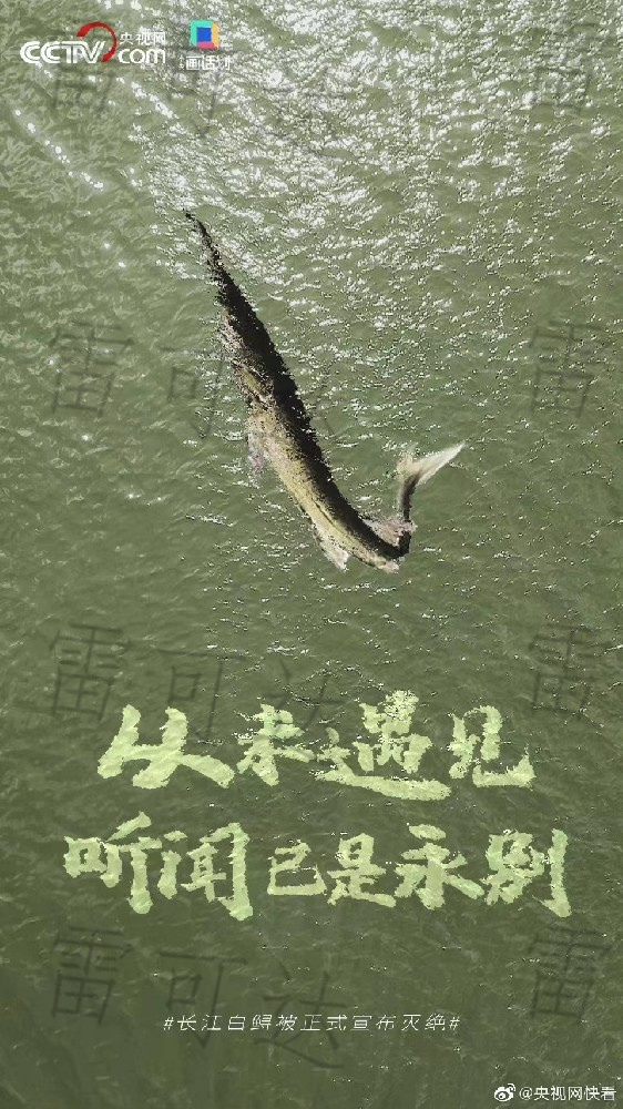
Winning the Protracted Battle of the Yangtze River Fishing Ban to Protect Biodiversity
On July 21, the International Union for Conservation of Nature announced the extinction of the Chinese paddlefish and the functional extinction of the Yangtze sturgeon in the wild. China is strengthening ecological restoration through the “Ten-Year Fishing Ban” and the Yangtze River Protection Law. The smart fishery administration system, utilizing radar and electro-optical technology, enables round-the-clock monitoring, providing technological support for fishing ban enforcement and contributing to the conservation of biodiversity in the Yangtze River.
Baca selengkapnya